Brief Description
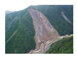
Geohazards exhibit various aspects wenomena, such as landslides, debris flow, soil eroson, liquefaction, settlement, in both natural and artificial geomaterials, depending on spatial distribution of topographic, hydrologic and geologic conditions. Potential of geo-hazards are also time varying due to the long-term phenomena such as regional tectonics and climate change, and also short-term processes, especially by heavy rainfall, snow melting, and earthquake shaking. Spatial and temporal prediction of geo-hazards, risk assessment and countermeasures against human, social and economic damages requires collaborative approaches across various scientific or engineering disciplines. We need tight coupling of updated scientific understanding of earth surface processes and latest technology in geotechnical engineering for developing, sharing, and generalizing the strategy for geo-hazard mitigation, with feedbacks from its social applications.
|
Activities
The 4th Slope Tectonics Conference was held at Kyoto University. There were two days meeting session held in Kyoto followed by a three-day field trip to the Kii Mountains, a world heritage site, in Kii Peninsula, Central Japan. The conference was held from 14 to 18 October 2017.
Workshop on "New Generation of Geohazard Mapping and Strategy for Its Social Application" at Disaster Prevention Research Institute (DPRI), Kyoto University, Uji Campus, Obaku Plaza on 12 March 2016.
GEMINI (Geohazard mitigation on the new innovation in science and engineering) is a project for developing, sharing and generalizing the strategy for geohazard mitigation.
|